

PyMapStitcher is a desktop application for creating large stitched map and satellite image outputs from user-selected map areas.
The app is designed for users who need high-resolution map imagery, large satellite views, or offline image exports for research, documentation, GIS-related workflows, archaeology, remote sensing, mapping, and visual analysis.
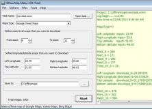
With PyMapStitcher, you can select map areas, download image tiles, stitch them into a single output, preview the result, and save the generated image locally on your device. The workflow is focused on practical desktop use: choose an area, process it locally, and export the result.
Key features:
Download and stitch large map or satellite image areas
Create high-resolution stitched outputs from map tiles
Preview generated results before export
Save processed images locally
Useful for GIS-related workflows, archaeology, documentation, research, mapping, and visual inspection
Local desktop workflow without requiring a user account
Simple standalone Windows app packaged for Microsoft Store distribution
PyMapStitcher processes user-selected files and generated outputs locally on the device. Some features may access online map or tile services when the user chooses to download map imagery. Users are responsible for complying with the terms of the map or satellite imagery providers they use.







Comments